 |
Tenerife Geology... |
|
Tenerife Geology... |
if you search for the "geology of Tenerife" you will come up with huge numbers of pages of varying detail. I'm not going to try and summarise all of the academic dicussions that are still taking place, this page is just intended to give a brief introduction to the geology of Tenerife as we saw it and the locations that we have visited. it is not an in-depth guide. For that there are a couple of publications that I would note and links are given below on places you can get them.
On our first trip to Tenerife we were not able to purchase a good geology guide, but if we had been able to wait just a couple more months then the excellent "Geologists Association guide to Tenerife" by Robin Gill & Matthew Thirlwall. Edited by J.T. Greensmith wouuld have been published. We used this and followed in particular Itinerary 2 which was the most local to where we were staying. A selection of the pictures were taken on that trip. Other pictures are just from our general adventures.
More recently there is the book "The Geology of the Canary Islands" which I have looked at a sample on-line and it seems to be an excellent book, but it is eye-wateringly expensive and I have therefore not read it and able to comment in more detail.
Before reading this page it may be useful for you to look at a Geolgical map of the Island. I have not found one that is not rights managed so I am not able to include one on this page. However there are quite a few online at various levels of complexity. Links to these are given here Simple Overview, and here Slightly more detailed,
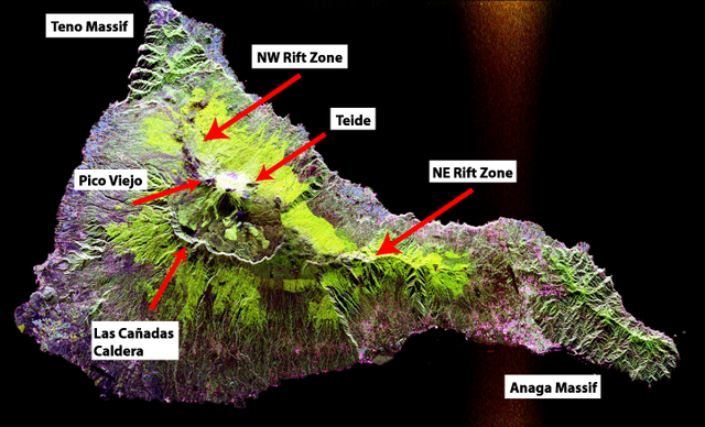
This overview based on a NASA image and in the public domain from Wikipedia gives a good idea of some key locations referenced below
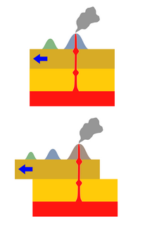
The classic interpretation of the formation of the Canary Islands including Lanzarote), and also that of Madiera and is that of a hotspot. A hotspot is a region where the mantle beneath is hotter than elsewhere which makes it more mobile and less dense. this molten or semi molten rock then rises in a plume staying more or less in one place as the crust of the earth moves across it by plate tectonics driven by other mantle currents. One scientific paper supporting this theory for all of these islands is here.
This view is not universally held as can be seen here.
This is one of the things that is constantly interesting about geology. as new information comes to light then new theories are proposed and its not unusual for professional and amateur geologists to be able to have a sensisble discussion on a topic of interest.
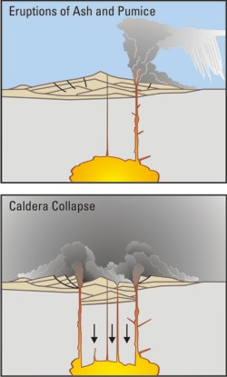 Image used under CC licence
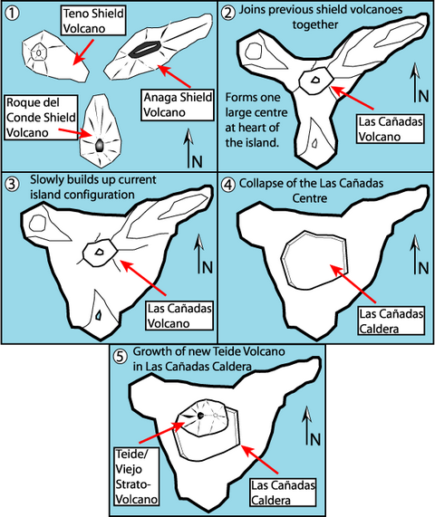
More locally, the island of Tenerife is belived to have been formed from three initial lslands (stage 1) these are the older rocks which can be found on the tips of the current island. These date back to the Miocene (up to 23 million years old) and Pliocene (up to 5.3 million years old).
These were then joined up by the Las Canadas volcano to form a single island (stages 2 and 3).
The top of this then collapsed (stage 4) to form the current Las Canadas caldera (caldera is the term for the landscape where there has been a collapse back into the earth as is shown in the picture on the right) and within that the Teide and Pico Viejo volcanic cones have erupted and grown (stage 5).
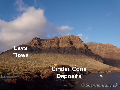
The Pictures in this section (picture numbers relate to the slideshow) These start in Buenavista / Punta de Teno (also shown here) which is a spectactular promentary on the Western side of Tenerife. What you are looking at are the remnants of a cinder cone of Miocene age These lava flows have been dated as being around 178 thousand years old. These come at the end of the documented tour, we were doing it backwards.
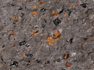
Pictures 3 & 4 are from stop 2.6 in the itinerary we followed where the dark pyroxine and orange olivine crystals can be seen as phenocrysts within the overall ankaramite lava (see picture on the right).
Phenocrysts are evidence of 2 phases of cooling and these are found here because they are formed in the type of volcanic activity related to "hotspots". The following two pictures are views along aroudn the area of Mirador de Cherfe which the road winds past giving an excellent place for a stop to admire the view. Here you can see an unconformity where near horizontal lavas have been laid down on top of other disturbed and alterd basalts.
At our next stop (pictures 7-10) we were able to see a layered instrusion formed by crystals of different sizes settling out from the liquid magma. These are cut by numerous near vertical dykes.
The next picture (picture 11) shows an entrance into the de El Palmar scoria cone which has been heavily quarried and therefore shows a number of interesting cross sections of the cone and provides an ability to get up close to the rocks. Pictures 12-15 are various close ups showing pummice blocks in the overall scoria deposits which have been laid down in layers as can be seen.
We finished this part of our trip at the spectacular cliffs of Los Gigantes where the sea is eroding into the massive lava pile from the Teno volcano creating these cliffs of up to 800 metres in height.
The next set of three (pictures 17-19) are the Columnar basalts on the beach at Los Silos where we stayed for both of our trips. The Columnar basalts are caused when cracks form around blocks of rock as they shrink slightly as they cool. Typically these form into hexagonal shapes when viewed from above. In these you can see that the edges of the blocks have weathered differently than the interior. This will be due to different phyical properties caused by the extra cooling at the edges.
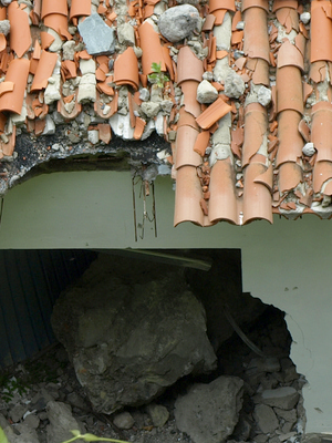
A trip to the nearby village of San Marcos shows the risk and folly of building close to unstable cliffs. The building with the red roof has been punctured on all sides and through the roof with massive blocks of rock. The one in the picture to the left is a block of rock the nearly size of a small family car. it was not possible to tell if these had all come down in one landslip event or over time since the building was abandoned, but clearly this was not a safe place to have built what looks to be a relatively new building.
If you are not convinced of the power of the earthquakes related to the volcanos in this area it is worth reading about these recent subsea eruptions on this BBC article
We then move onto the main sequence of pictures which are all taken on the foothills and peaks of Mount Teide.
At 3,718 metres (12,198 feet) above sea level, Mount Teide is the highest mountain in Spain and in all of the Atlantic archipelagos. Given that it is only a few miles from the sea and that you can drive, cablecar and walk to the summit in just a few hours it is the fastest way to get the adverse efects of altitude that I know (I did struggle to breath well at the summit if you are doing it be careful!). If measured from the ocean floor, it is at 7,500 m (24,600 ft) the fourth-highest volcano in the world
it is a truly wonderful place to visit as a Geologist and photographer, as it says on the UNESCO site
Rising 7,500 m above the ocean floor, it is regarded as the worlds third-tallest volcanic structure and stands in a spectacular environment. The visual impact of the site is all the greater due to atmospheric conditions that create constantly changing textures and tones in the landscape and a sea of clouds that forms a visually impressive backdrop to the mountain. Teide is of global importance in providing evidence of the geological processes that underpin the evolution of oceanic islands.
Criterion (vii): Mount Teide is a striking volcanic landscape dominated by the jagged Las Cañadas escarpment and a central volcano that makes Tenerife the third tallest volcanic structure in the world. Within this landscape is a superlative suite of landforms that reveal different phases of construction and remodeling of the volcanic complex and highlight its unique geodiversity. The visual impact is emphasized by atmospheric conditions that create constantly changing textures and tones in the landscape and a sea of clouds' that forms a visually impressive backdrop to the mountain.
Criterion (viii): Teide National Park is an exceptional example of a relatively old, slow moving, geologically complex and mature volcanic system. It is of global importance in providing diverse evidence of the geological processes that underpin the evolution of oceanic islands, and these values complement those of existing volcanic properties on the World Heritage List, such as the Hawaii Volcanoes National Park. It offers a diverse and accessible assemblage of volcanic features and landscapes in a relatively limited area. The area is a major centre for international research with a long history of influence on geology and geomorphology especially through the work of von Humboldt, von Buch and Lyell which has made Mount Teide a significant site in the history of volcanology.
As described above "Mount Teide" is a stratovolcano, also known as a composite volcano, is a conical volcano built up by many layers (strata) of hardened lava, tephra, pumice and ash. The Current cones of Teide and Pico Viejo sit within the Las Canadas caldera
Each picture has a brief description on it, Here I will provide a bit more information on selected pictures
Pictures 24 and 25 show radial columnar jointing. The reason for this must be differential cooling coming from all sides of the rock. Whether that is caused by cracks growing out from the center as described in this article, or because the lava was emplaced into an existing lava tube where the surrounding rock was already cooled will need a lot more work to consider than I am able to do.
Picture 28 Shows the tip of a lava flow which has creted the ridge, but has not had sufficient flow behind it to continue. The tip is a rubbly form of Pahoehoe (ropy) lava.
Picture 29 shows a piece of hard dark fine grained basalt which is the most typical rock in the caldera.
Pictures 31 to 33 show lava flows from the Teide volcano spreading out across the floor of the Las Canadas calders
Picture 39 shows an interesting green colour. This is not as some people have suggested anything to do with copper. it is green chlorite clay minerals. "Chlorite" is the name of a group of common sheet silicate minerals that form during the early stages of metamorphism so these rocks have been cooked since they were originally laid down.
Pictures 41 to 43 show a recent (in geological terms) eruption which has come across an area where the rocks hadd been weathered into usable soils. You can see the areas that are being used for crops surrounded by the dark lava
Pictures 45 and 46 show the Pico Viejo volcanic cones which have erupted in historical times with a good record. The vents here on the side of the main cone were opened during an eruption which stated on June 9th 1798 with an explosive event which hurled ash 1000m int the sky, some were found as rar away as El Heirro and Gran Canaria. The Eruptions continued for 92 days and the lavas have covered around 5km 2
Picture 47 shows an outcrop of basalt that has been sampled by a geologist for analysis back in the laboratory. This could have been for chemical analaysis of the rock, but is more likely (because that could have been done with a block that was simply hammered off) to have been for palaeomagnetic studies. These are used to date the rocks because the earth's magnetic poles move around and changes can be tracked in the rocks.
Pictures 49 and 50 are of ash that has been weathered
Pictures 51 to 54 are sulphur deposits coming from steam vents near the top of Mount Teide. The yellow colour of native sulphur can be seen in the close up picture
Pictures 61 to 63 are of colcanic bombs where a lump of lava has been thrown into the air and has then landed on the existing deposits (in this case ash) and has deformed the layers it has impacted.
Pictures 64 to 66 are of the The Montana Negrita "paintbox curves". The white layers are of light, porous, pumice fragments which came from a plinian eruption with a lot of gas in the lava which expanded into bubbles as it was erupted. This pummice could have been thrown up to 20Km into the air and carried by the wind. The black layers are of basalt lapilli from a much lower gassy Strombolian eruption and probably from a much closer source because they would not have been thrown so hight into the air (maybe 1-2Km). The reddish layers are of basalt which has been oxidised by ground water
Pictures 67 and 68 are of a hard dyke that was emplaced into much softer rocks which have been weathered away leaving the dyke as an upright feature
As well as those provided above here are a few more useful links
http://en.wikipedia.org/wiki/Tenerife
https://geologistsassociation.org.uk/guidesales/ Excellent book at a very reasonable price
https://en.wikipedia.org/wiki/Teide
https://www.amazon.co.uk/Geology-Canary-Islands-Valentin-Troll-ebook/dp/B01GA0OO8M/ref=sr_1_1 Very comprehensive but eye wateringly expensive
https://lithics.wordpress.com/2011/11/11/a-canarian-comparison/